By Leslie Adams, Incredible Memories Travel
You may think of San Diego as a summer destination of sunny beaches and the world-famous San Diego Zoo, but there’s more to California’s second-largest city than that! San Diego County is considered a “biodiversity hotspot,” as the area contains the greatest diversity of life in the continental United States, and it’s a great year-round destination. You can get out and explore the incredible variety of life by taking one of the following hikes during your visit to “America’s Finest City!” Here are some of the top hikes in the region, along with their accessibility and alternatives. All distances are round-trip unless otherwise noted. Check the hourly weather before you head out, as some of these hikes can get very hot in the summer months.
Further resources: https://wheelingcalscoast.org/county.php?county=1
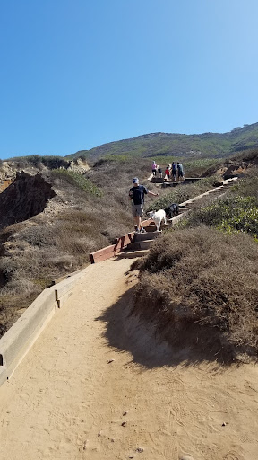
1) Cowles Mountain
This iconic hike in San Diego’s Mission Trails Regional Park traverses 1.5 miles to the top of the highest peak within the city limits (3 miles round-trip). You will enjoy the California sage scrub plant community, and possibly see some common Southern Californian animals such as roadrunners, Cooper’s or red-tailed hawks, Western fence lizards, and/or rattlesnakes. Stop by the excellent visitor center (1 Father Junipero Serra Trail, San Diego 92119) before your hike to get a trail map and view the displays about the native inhabitants of this land as well as the plants & animals. This is a popular hike and is often quite crowded; avoid the masses by going on a weekday and/or hiking from the trailhead at Barker Way. If you want more solitude, continue 1.5 miles from the radio tower at the Cowles Mtn Peak to the summit of Pyles Peak – this addition will add 3 miles to the overall hike.
Best season to hike: winter, spring
Accessibility: not accessible to wheelchair users; good alternative is the nearby paved path around Mission Trails’ Lake Murray (6.4 miles out-and-back)
More info: https://mtrp.org/trail-maps/

Switchbacks on Cowles Mtn
2) Mission Trails Regional Park
More of a full-service destination than just one hike, Mission Trails is a great option for the whole family! The #1 hike above, Cowles Mtn, is in Mission Trails, as are four more of the “MTRP 5 Peaks”: North Fortuna, South Fortuna, Kwaay Paay, and Pyles Peak. Some experienced hikers attempt to hike all five peaks in one day, but we only recommend trying this 20+ mile trek if you’re in excellent shape. For families, we recommend visiting the first-rate Visitor Center to view the exhibits about the flora & fauna of the area, as well as to pick up a map and get the schedule of ranger-led nature walks. The wheelchair- and stroller-friendly Father Junipero Serra Rd, which has a protected bike/pedestrian path, can be accessed from here, and taken 0.7 miles to the Old Mission Dam, which is an interesting historical feature. The Oak Canyon Loop is a 1.7 mile family-friendly loop in the Old Mission Dam area – this area is the most fun after winter/spring rains, when the seasonal streams fill and ephemeral waterfalls can be found by intrepid explorers! More difficult hikes are the Fortunas and Kwaay Paay Peak. (For information about Cowles & Pyles, see #1)2) Mission Trails Regional Park
Best season to hike: fall, winter, spring; early morning or evening in summer
Accessibility: varies; see details in description
More info: www.mtrp.org

Old Mission Dam
3) Woodson Mountain/Potato Chip Rock
This is the hike you’ve seen on all the Instagram influencers’ feeds! You have your choice of multiple routes: the short (4.2 miles round-trip), steep (6°/11%) paved service road from Hwy 67 is accessible; the most scenic non-accessible route is the Fry-Koegel trail (about 7 miles RT). Both will take you to a boulder with a rock “flake” that sticks up like a potato chip – hence the name. This is a popular hike that generally has a line to access the boulder for a photo, so prepare for a wait, or go on a weekday. This mountain is a good representative of the typical boulder-strewn peaks found throughout the county. Keep an eye out for birds of prey such as hawks and golden eagles, and watch the ground for shy reptiles such as the Western fence lizard and Southern Pacific rattlesnake.
Best season to hike: fall, winter, spring
Accessibility: paved service road may be done with wheelchairs or strollers with a strong assistant; however, Potato Chip Rock has to be jumped onto from a nearby boulder.
More info: https://modernhiker.com/hike/hike-woodson-mountain/

“Potato Chip Rock” on Woodson Mt
4) Torrey Pines State Natural Reserve
Torrey Pines SNR is home to the U.S.’s rarest pine tree, which only grows in this protected area and on Santa Rosa Island in Channel Islands National Park off the California coast. There are several accessible trails that allow wheelchair & stroller users to observe these trees and this fragile ecosystem, as well as non-accessible trails down to the beach. There is an entrance fee and to protect the plants & animals, food & drink may not be brought into this special place.
Best season to hike: year-round
Accessibility: see list of accessible trails here: http://access.parks.ca.gov/parkinfo.asp?park=256&type=0
More info: https://www.parks.ca.gov/?page_id=657

Torrey Pines SNR (photo by Conni Nardo)
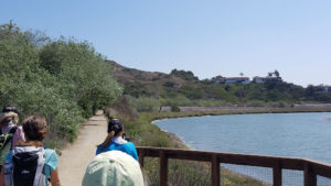
5) Los Peñasquitos Canyon Preserve
This seven-mile long canyon stretches from Interstate 805 to the west to Interstate 15 to the east. It’s fairly flat, and thus wheelchair- and stroller-friendly unless it’s rained recently, in which case the area closes to allow the delicate ecosystem to avoid damage. You can find evidence of habitation both prehistoric and historic in this area. In addition to a small waterfall area, many California live oaks and sycamore trees grow here, and birds such as Great Blue Herons, fish such as largemouth bass, amphibians such as the Pacific tree frog, and mammals such as mule deer & bobcats can be found here.
Best season to hike: year-round
Accessibility: wheelchair & stroller-friendly
More info: https://www.sandiego.gov/park-and-recreation/parks/osp/lospenasquitos

Los Peñasquitos Canyon Preserve
6) Cabrillo National Monument, Coastal Trail
This moderate one mile hike has amazing views of the Pacific Ocean as you traverse along the high bluffs of Cabrillo National Monument, passing through areas of native shrubs such as Mediterranean Coastal Sage Scrub and Maritime Chaparral, along with some resurging native sea dahlia flowers. There are several short flights of stairs on this trail, hampering accessibility. At the southern end of the trail, you can join up with the wide gravel walkway that leads to the tide pool area. While the pools themselves aren’t accessible, there is a bench at the end of the trail where you can rest and enjoy the views. There is an entrance fee to this National Park Service unit.
Best season to hike: year-round
Accessibility: varies; see https://www.nps.gov/cabr/planyourvisit/mobilityservices.htm
More info: https://www.nps.gov/cabr/learn/coastal-trail.htm

Coastal Trail, Cabrillo NM
7) Eagle Rock via Pacific Crest Trail
Probably the most anthropomorphic rock formation in the world, this 6.5 mile hike is a moderate hike along the world-renowned Pacific Crest Trail that is accessible to jogging strollers and other conveyances with large wheels. You’ll pass through prime riparian habitat (along a stream), then walk through coastal sage scrub, and finally approach the pile of boulders topping a hill amongst rolling grassland. Note that you can’t tell that it’s an eagle until you walk around it!
Best season to hike: winter, spring
Accessibility: jogging strollers
More info: http://hikingsdcounty.com/eagle-rock/

Eagle Rock via the PCT
8) Stonewall Peak, Cuyamaca Rancho State Park
An adventure almost every step, this 3.8 mile hike follows gentle switchbacks up the side of a prominent peak in Cuyamaca Rancho State Park (admitting personal bias: this hike is my family’s favorite one in the county). With ceanothus (mountain lilac) shading much of the lower trail, this hike is often cooler than others that cross exposed slopes, though that also means that snow hangs around longer in the spring. The smell when the ceanothus is blooming (approx. March to May) is enchanting! When you approach the top, you will climb up granite rock slopes, then ascend a masterfully-engineered rock stairway to the top, where you’ll be rewarded with 360-degree views of the county’s backcountry, as well as far-off peaks. Day use fee.
Best season to hike: fall, winter, spring
Accessibility: not accessible; alternative: nearby Cuyamaca Peak has a paved road to the top & similar views
More info: https://modernhiker.com/hike/hike-stonewall-peak/

Admiring view from Stonewall Peak Trail
9) San Elijo Lagoon Ecological Reserve
This lagoon is home to many different types of birds, both migrating and native, as well as excellent specimens of native plants. A nature center built using “green” techniques highlights water conservation and storm water pollution, and an accessible interpretive path highlight the flora & fauna found in the area. Those without physical conditions, claustrophobia, or agoraphobia are sure to enjoy the Annie’s Canyon Trail to the south of the lagoon.
https://thenaturecollective.org/location/annies-canyon-trail/.
Best season to hike: year-round
Accessibility: most trails are flat and/or paved. https://wheelingcalscoast.org/site.php?site=50
More info: https://www.sdparks.org/content/sdparks/en/park-pages/SanElijo.html
-
San Elijo Lagoon
10) Black Mountain, Trail for All People
This fully accessible 0.2 mile loop in the Black Mountain Regional Park was built specifically for those with mobility issues to enjoy the views. There are interpretive signs along the route, along with four shade structures that can accommodate a wheelchair. On a clear day, you can see the ocean in the distance, and perhaps snow-capped peaks to the north and east. Ambitious hikers can take the service road “trail” to the peak.
Best season to hike: fall, winter, spring
Accessibility: Trail for All People is fully accessible; service road to top accessibility depends on recent weather
More info: https://www.sandiego.gov/park-and-recreation/parks/trail-for-all-people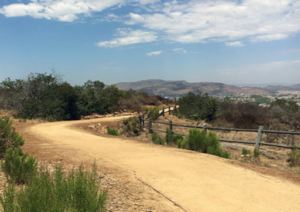
Black Mountain Trail for All People (photo by City of San Diego)